
International
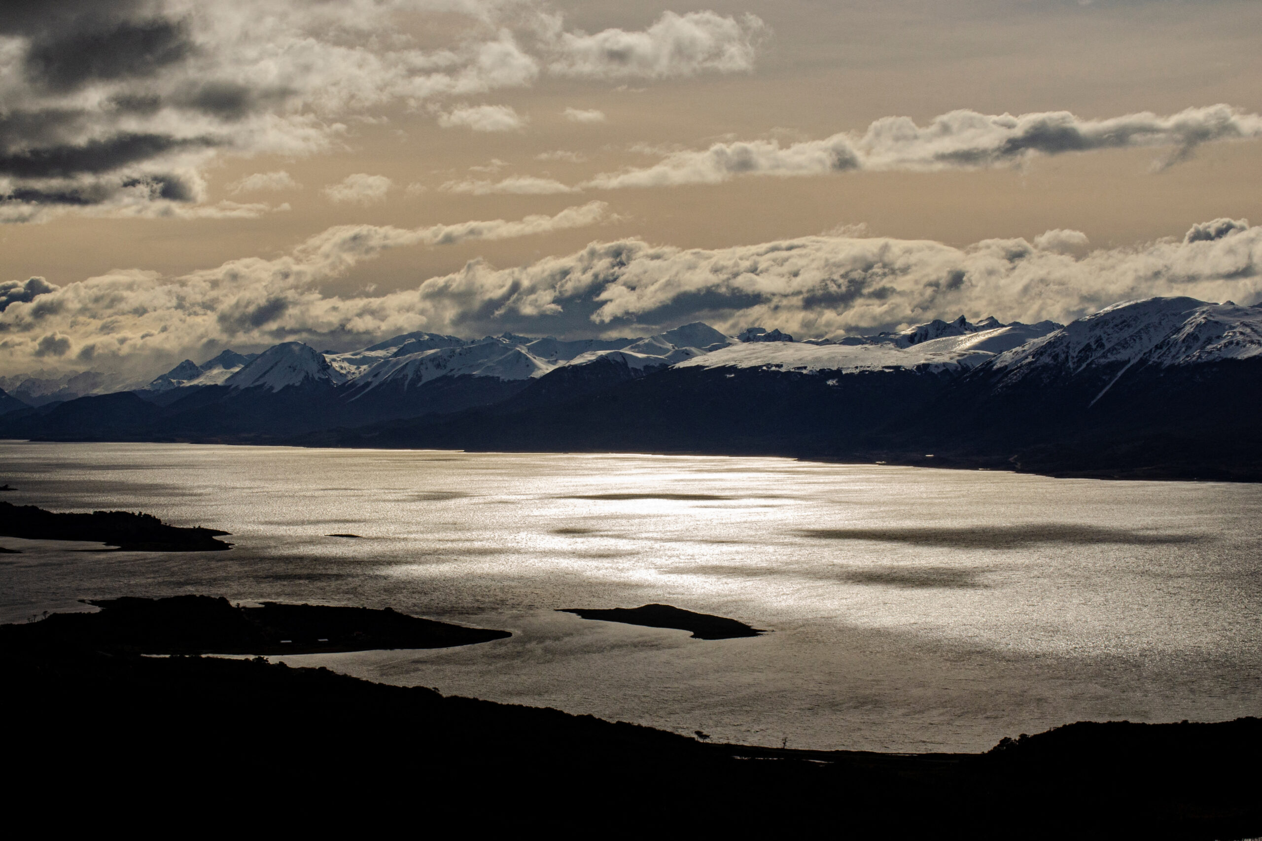
Chile’s distant paradise where scientists study climate change
AFP | Alberto Peña
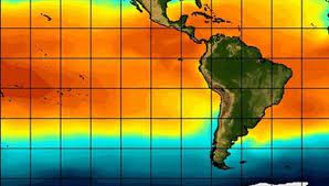
Hidden inside pristine forests in Chile’s deep south, known as the end of the world, lie potential early warning signs of climate change. Puerto Williams on Navarino island, which is separated from the South American mainland by the Beagle Channel, is the world’s southern-most town.
Far from the pollution that blights major urban and industrial centers, it is a paradise that provides unique conditions to study global warming.
“There is nowhere else like it,” Ricardo Rozzi, director of the Cape Horn International Center for global change studies and bio-cultural conservation in Puerto Williams, told AFP.
It is “a place that is especially sensitive to climate change” as average temperatures do not rise above five degrees Celsius. This cold and windy area is the last inhabited southern frontier before reaching the Antarctic.


The ethnobotanical Omora park is home to an immense variety of lichens, mosses and fungi that scientists study by crouching down onto their knees with magnifying glasses.
In the crystal clear Robalo river, minuscule organisms act as sentinels of the changes produced by global warming. In both the park and river, the alarm bells are ringing.
Moss and lichen on the move
At this latitude — 55 degrees south — climate change has an exponential effect on flora that react by seeking out low temperatures, said Rozzi, 61. “The most obvious aspect of climate change is the rising temperatures,” he said. “These lichens cannot survive” if a certain threshold is passed. To escape the higher temperatures, they move.
“In the case of (mosses) we’ve noticed that they have moved. Before they were between 50 and 350 (meters above sea level) and now they are between 100 and 400,” said Rozzi. He says Omora has more diversity per square meter of lichens and mosses than anywhere else in the world. They also help to absorb carbon dioxide.
Another aspect is the elevational diversity gradient, an ecological pattern in which biodiversity changes with elevation.
The 700-meter high Bandera hill’s biodiversity changes every 200 meters and there is a mammoth 1.5 degrees Celsius difference in temperature between top and bottom.
“We can see what changes happen in the high mountains and in the area close to the sea in a very short distance, and we can see how the temperature affects the biodiversity that lives in this river,” Tamara Contador, 38, a biologist at the Cape Horn International Center, told AFP.
She studies the gradients themselves. If the height difference between gradients rises or falls on the mountain, scientists can determine whether there has been a global change in temperature. They say there has been.
Avoiding ‘extermination’
“On a global level, the polar and subpolar ecosystems are the most affected by climate change, so we are in a place where climate change has a much bigger effect on biodiversity than other places,” said Contador.
River organisms also form part of the alert system.
“The organisms that live here are also indicators of water quality and global environmental change,” added Contador.
River organisms move about and have already increased their reproductive cycle, says Rozzi. This confirms there has been a small change to the climate in the area that could have been much greater elsewhere on the planet.
“Some insects that have an annual eggs to larvae to adulthood cycle are now having two cycles because the temperature has risen,” said Rozzi.
By studying these organisms and learning from them “we can avoid crossing the threshold that brings us to the extermination of humanity and other life forms,” he added.
-
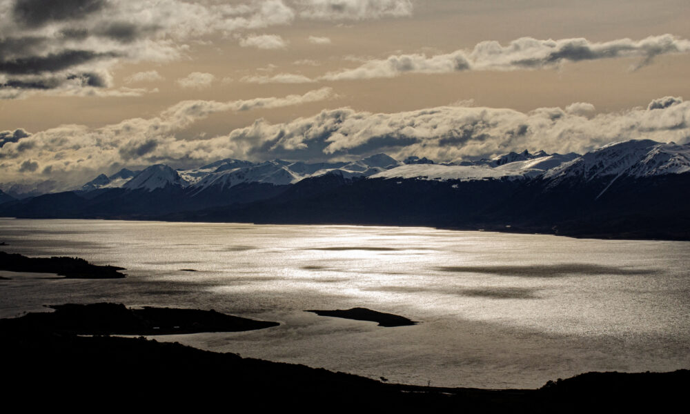
A glacier over Darwin's mountain range is seen during a journey through the Beagle Channel in the Magallanes region, the southernmost of Chile, on September 23, 2022. - There is a place at the end of the world, in the southernmost point of Chile, where pristine forests hide tiny systems in their depths that already give early warning of the global climate change that the planet is suffering. Beyond the place where the American continent ends, on Navarino Island, crossing the Beagle Channel, Puerto Williams stands as the southernmost city in the world, a place far from pollution and human mistreatment, with unique conditions for the study of climate change. (Photo by Alberto PEÑA / AFP)


International
Truck bomb attack near police station in Colombia leaves 14 injured ahead of presidential inauguration
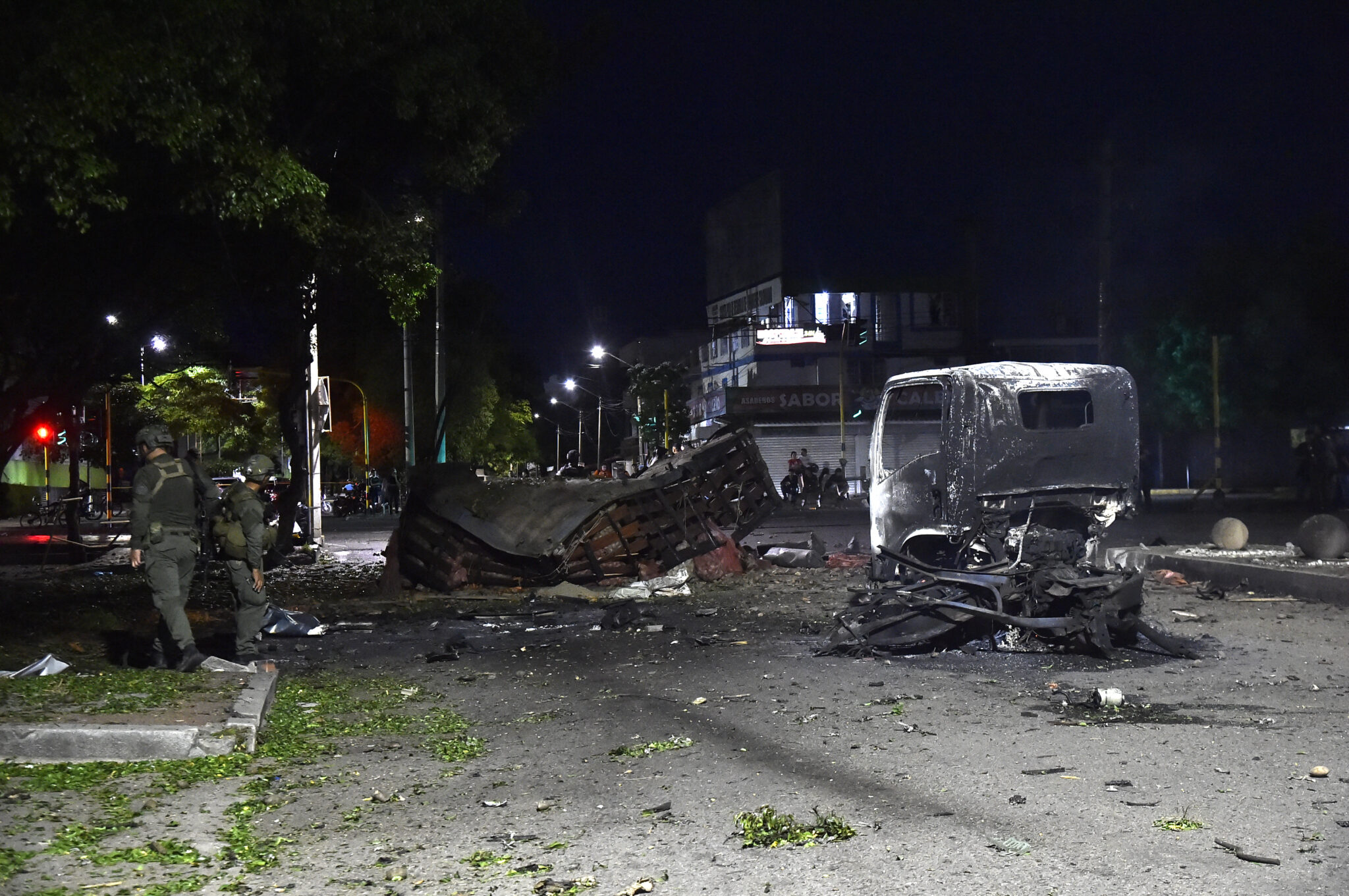
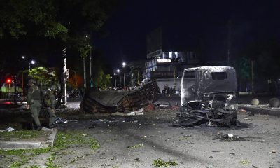
A truck loaded with explosives exploded on Saturday near a police station in the Colombian city of Cúcuta, close to the Venezuelan border, leaving 14 people injured in an attack that occurred six days before president-elect Abelardo de la Espriella’s inauguration.
The blast took place in the early hours of the morning and was allegedly carried out by members of the National Liberation Army (ELN), who detonated a vehicle packed with explosives. According to the latest report from the Colombian Army, the attack injured 11 police officers and three civilians.
The explosion involved around 15 explosive devices, and two of the wounded officers are in critical condition and “fighting for their lives,” said William Villamizar, governor of Norte de Santander, the region where the attack occurred.
The incident comes amid Colombia’s worst wave of violence in the past decade, with armed groups expanding their presence in several areas of the country.
“I strongly condemn the cowardly terrorist attack carried out in Cúcuta against our National Police. Terrorism will not intimidate Colombia or break the determination of Colombians to live in peace and security,” De la Espriella said in a post on X.
The conservative lawyer, who has been described as a far-right figure, will take office on August 7, replacing Gustavo Petro, Colombia’s first left-wing president. The inauguration ceremony will be held in Cali, the country’s third-largest city and a frequent target of attacks by armed groups.
The United Nations condemned what it described as an “indiscriminate attack” that caused not only injuries but also “fear and distress among the population.”
De la Espriella has repeatedly warned about an alleged plot against his life. Meanwhile, President Gustavo Petro, who is currently visiting Cuba, has not commented on the attack. During his visit, Petro met with Cuban President Miguel Díaz-Canel to discuss what Havana describes as the United States’ “policy of suffocation” toward the island.
International
EU Faces Migration Crisis After 60,000 Migrants Arrive in Spain’s Ceuta Enclave
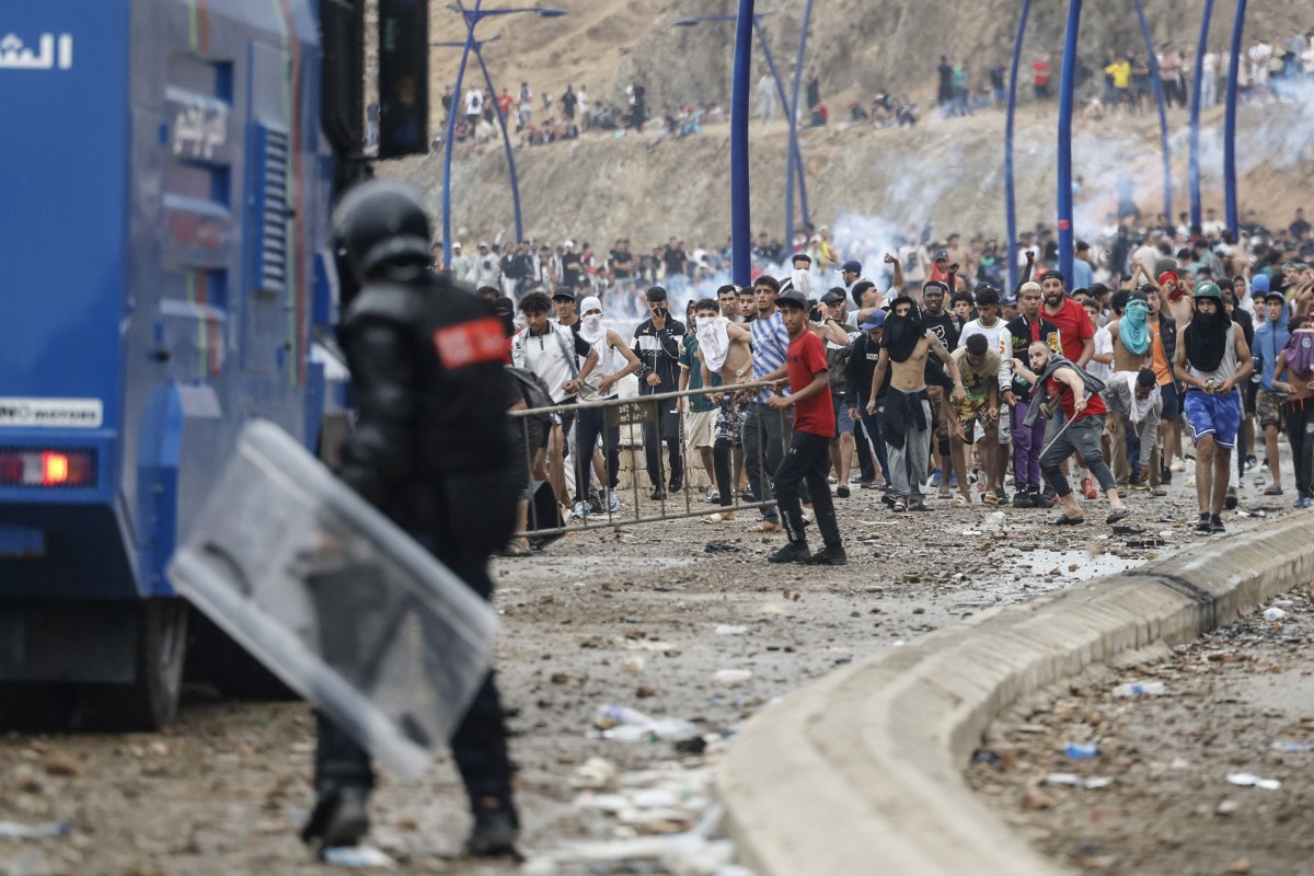
The arrival of around 60,000 migrants from Morocco to Spain’s Ceuta enclave triggered a major European Union crisis on Friday, after Madrid described the situation as an “attack” on its territorial integrity.
At least 34 people died while attempting to reach the Spanish territory, according to local authorities.
Hundreds of migrants had begun arriving in Ceuta earlier in the week, either by swimming across the border or climbing security fences. Most of those who entered were young men and teenagers.
However, the situation escalated dramatically early Thursday morning, when the number of arrivals surged within a few hours, reaching nearly 60,000 people. According to the Spanish government, the vast majority of them — around 48,000 migrants — had returned to Morocco by Friday evening.
The episode represents one of the most serious migration crises faced by the autonomous city of Ceuta, which has a population of around 84,000 residents, in recent years.
Several European countries responded strongly to the crisis, with Italy announcing the temporary suspension of the Schengen free movement agreement with Spain, a measure supported by Finland and Denmark.
“The temporary suspension of Schengen with Spain is a necessary decision to protect the security of our citizens and defend Europe’s borders,” Italian Foreign Minister Antonio Tajani said in a post on X.
Italy’s Interior Ministry confirmed that the country had tightened controls on maritime and air entry points from Spain, but clarified that the measure would not affect Spanish or European citizens traveling to Italy.
The additional checks will specifically target non-European citizens arriving from Spain, according to the ministry.
The measure will remain in effect for one month starting Saturday, authorities said.
Spain’s Foreign Minister José Manuel Albares responded to the Italian announcement through a statement on X, as European governments continued discussions over the consequences of the migration crisis.
International
Chuck Schumer Unveils Proposal to Strengthen Oversight of the U.S. Presidency
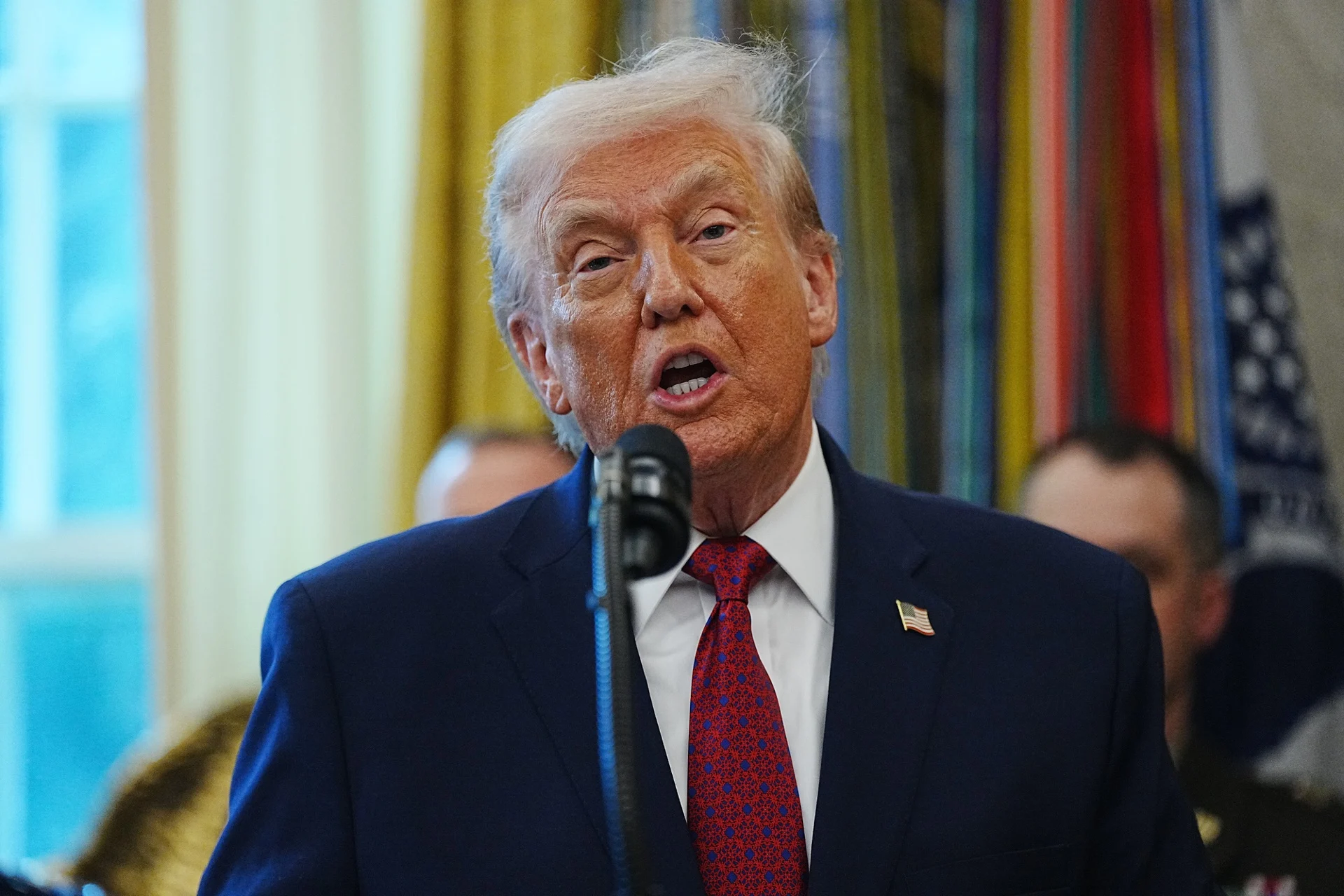
U.S. Senate Democratic Leader Chuck Schumer on Thursday announced legislation to establish a federal anti-corruption office aimed at strengthening oversight of the executive branch and preventing future presidents from using the White House for personal financial gain.
Schumer said the proposal was prompted by what he described as President Donald Trump’s misuse of the presidencyto benefit his family’s business interests.
“In just 18 months, the Trump family has made more than $4 billion by exploiting the influence of the presidency,” Schumer alleged.
The New York senator also argued that the alleged corruption has had direct economic consequences for American households.
“The same corrupt practices Trump is using to pocket billions of dollars are also forcing Americans to pay, on average, $3,100 more each year because of the rising cost of living,” he said.
The legislation was introduced alongside Democratic Senators Alex Padilla, Jeff Merkley, and Andy Kim.
According to Schumer, the bill has two primary objectives: “First, to return money to the American people. Second, to ensure that no one can ever steal from them again.”
He added that the proposal would create legal mechanisms allowing citizens to seek the recovery of funds allegedly obtained through government corruption.
“The fact that Trump stole money from the American people does not make it his. Americans deserve to get that money back,” Schumer said.
Under the proposed legislation, any U.S. citizen—as well as state attorneys general acting on behalf of their residents—would be authorized to file civil lawsuits to recover funds allegedly acquired through corrupt practices by public officials.
“Our bill would empower any individual, including a state attorney general acting on behalf of the people of that state, to bring legal action to recover money stolen from the public through government corruption,” Schumer said.
The measure is expected to face debate in Congress, where Republicans and Democrats remain deeply divided over executive accountability and the scope of presidential powers.

Truck bomb attack near police station in Colombia leaves 14 injured ahead of presidential inauguration

EU Faces Migration Crisis After 60,000 Migrants Arrive in Spain’s Ceuta Enclave

Chuck Schumer Unveils Proposal to Strengthen Oversight of the U.S. Presidency
Tec de Monterrey honors one of its students for his contribution to nanotechnology in medicine

Defense Minister commends salvadoran soldier for Central American Cross Country victory

Extension of the state of emergency approved in southern Chile
-
 International3 days ago
EU Faces Migration Crisis After 60,000 Migrants Arrive in Spain’s Ceuta Enclave
-
 International5 days ago
Five Bodies Found in Ecuador as Police Probe Suspected Gang Turf War
-
 International4 days ago
Chuck Schumer Unveils Proposal to Strengthen Oversight of the U.S. Presidency
-

 International5 days ago
Georgia Teen Sentenced to Life Without Parole for Deadly School Shooting
-
 Central America5 days ago
Prosecutors Accuse Ex-Defense Minister of Undermining Press Freedom in Honduras
-
 International4 days ago
FAO and WFP Seek $42 Million to Prepare Southern Africa for Unprecedented El Niño
-
 International4 days ago
Trump Administration Urges Latin America to Increase Defense Spending Against Organized Crime
-
 International1 day ago
Truck bomb attack near police station in Colombia leaves 14 injured ahead of presidential inauguration